
Brazil’s highest court has decided unanimously to accept an appeal from an indigenous forest tribe that has been fighting for access to its original ancestral lands for decades. While lawyers hailed this as a significant decision because it means the Guarani Kaiowá will be able to speak on their own behalf for the first time, it seems unlikely they will ever be able to return to their traditional ways because of the way in which those lands have been developed.
The Guarani-Kaiowa claim to the Guyraroka land was recognized in 2004 and the federal agency that demarcates land began that process in 2009. But the process went slowly, with threats, denied access to land, and agribusiness pressure on the government. In 2014, the court ruled against their land claim on the ‘catch-22’ basis that the tribe had not been living on the land when the Brazilian constitution came into force in 1988.
But last week, the court said that the 2014 decision could be appealed and reviewed because the legal proceedings had lacked input from the Indigenous community. It is a sad but not untypical story. Their ancestral lands in Mato Grosso do Sul state have been whittled away over the years, forcing them on to small reserves even as their land was cleared for farming, ranching, and increasingly, soy and sugar cane cultivation as part of the biofuels boom. The forests in which they once hunted and fished have been cleared, the reservations are small and overcrowded, and they often are forced to rely on labouring on sugar cane plantations. As in many places, there is a huge discrepancy between their rights on paper and what actually happens on the ground.
Being able to present the court with a map developed from their own knowledge would be a good start. And there is a technique called participatory mapping that has been developed and used for that purpose for almost half a century.
While the story of Brazilian development, deforestation and denial of indigenous rights is a depressing one, it is worthwhile noting that the process of mapping territory has been a positive one in many places. The participatory mapping process allows communities to translate their stories and knowledge of places into physical maps – sometimes even dioramas – that can be used to demonstrate and exercise their rights. It means that when they talk to the government or corporations, they have a physical model of their community’s land use practices to which they can refer.
Mapping For Rights, which works on rainforest protection in the Congo, explains it this way: “Also referred to as ‘community mapping’, it is based on the premise that local inhabitants hold accurate knowledge of their customary (and otherwise usually unrecorded) tenure of forests, as well as expert knowledge of their local environments which can be expressed in maps which are easily understandable. Maps created by local communities represent the place in which they live, showing features communities themselves perceive as important such as customary land boundaries, how they use the forest, sacred areas, and so on.”
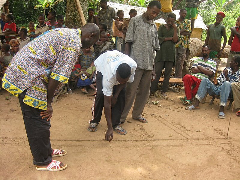
There are quite sophisticated systems in use these days but mapping can also be done by drawing on sand or earth in a communal village space that might, for example, use stones or seeds to show buildings or specific places of value. The idea is to bring the whole community together to share their knowledge, so that the map reflects everyone’s input. Thus it is just as much about sharing stories as it is drawing lines in the dirt or on paper.
A whole series of maps can be scaled up into an atlas. Mapping for Rights’ Congo Basin Community Atlas contains more than 1,000 maps covering more than nine million hectares. The maps were produced by forest communities “through low-cost, easy-to-use mobile applications” and show villages, forest cover, state services, and land use activities such as logging, agriculture, and protected areas.
The organization has gone beyond mapping to monitoring in real time. It points out that many observation programs depend on sending expensive field missions, and that satellite monitoring can show forest loss but not necessarily what is causing it. “Our community forest monitoring initiative aims to change this by unlocking the potential of traditional forest guardians in monitoring and protecting their forest lands. At the heart of this is ForestLink – a breakthrough system that enables communities to transmit highly accurate and low cost geographical alerts on illegal forest activities in real-time – even in remote areas where there are no telecommunication networks.”
The Participatory Mapping Institute has an internationally-led project in Norway that looks at how industrial growth affects indigenous people and how indigenous knowledge systems affect environmental decision making. But exploring its site shows just how dramatically the use of participatory mapping has expanded in recent years, with the goal of making better decisions that involve wide participation. One theme, for example, involves exploring how children live in and use cities.
In 2014, Jo Guldi of Brown University wrote a fascinating article, Can participatory mapping save the commons? Technology has made it possible to crowd-source maps these days, but this awareness of the power of shared information grew out of the participatory mapping that started offline in the 1970s. It gave communities a tool to exercise their shared power over shared resources.
“This flies in the face of the traditional logic of the map. Maps were originally disseminated across the world in the seventeenth century as a tool of privatization”, she says. “Conveniently, settlers typically traveled with surveyors to make the maps, along with armies to back up the documents. So, when native peoples began making their own maps of ancestral territory in the 1970s, pooling the testimony of hundreds of inhabitants to prove to courts that they were not dead and they were, still, in fact, inhabiting the places deeded to their ancestors, those maps amounted to a reversal of the logic of colonization. Private maps made private property; they were invented for that purpose. Crowdsourced maps were invented to unmake it, and have been used successfully to that end ever since.”
Ushahidi, which grew out of an informally developed response to election violence in Kenya some years ago, has developed a range of tools to allow widespread public participation in election monitoring, crisis response, and advocacy and human rights. In April, its platform was used to map hand washing stations in Indonesia to help prevent the spread of Covid-19.
The ultimate example of participatory mapping may be the Open Street Map, which is a bit like a wikipedia for places. Its goal is “to create and provide free geographic data, such as street maps, to anyone.” It is run by an international not-for-profit foundation whose aim is to provide free geospatial data for anyone to use and share.
Sources:
Landmark decision: Brazil Supreme Court sides with Indigenous land rights. Mongabay, Apr. 13, 2021
The struggle of the Guarani-Kaiowá: Land shortage and hunger in a land of plenty. FIAN fact sheet, Dec. 2013
Guarani Indigenous men brutalized in Brazilian ‘expansion of violence’. Mongabay, Mar. 24, 2021
A new approach to participatory mapping. MappingRights, April 2015.
Can Participatory Mapping Save the Commons? Jo Guldi, Jan. 21, 2014
